Wednesday, December 31, 2008

Picture of the Day – Leavenworth Iris


Happy New Year, one and all. I chose this picture to remind you all, especially those of you experiencing a very severe winter, that better days are just ahead. The plant that created this beautiful flower is well underneath many inches of snow right now. But before long, the snow will be gone and the plant will produce another masterpiece like this one.

The hours of sunlight are also on the rise. After December 21, the days get longer and the nights shorter. We all may have some more bad weather to go through, but it will end and the cycle of renewal will begin again.

So it is with all of life…there are better days ahead. Enjoy this day, then do the same thing tomorrow. We will get through any difficult days ahead and be stronger for it.

I wish you a very happy and prosperous 2009.

Monday, December 29, 2008

Pictures of the Day – More from the Canyonlands


As I mentioned in my last blog, “Island in the Sky” in Canyonlands National Park is all about the views, I thought I would share a couple of more pictures of those views. Perhaps I did the park an injustice in my last blog, but I was disappointed from a photographic standpoint.

As you can see, the light that day was diffused because of the clouds. In other words, you don’t see any shadows. Good for photographing flowers, not for views, as a rule.

Anyway, these are just a couple of the spectacular views you see from Island. In the first picture, the river you see is the Green River. Not to far from here, the Green River flows into the Colorado River.

All of this area and more was first explored by John Wesley Powell in the 1867. Powell was a very interesting character in our history. He lost an arm in the Battle of Shilo during the Civil War. His expeditions down the Colorado River are famous as he explored what is now the Canyonlands, Grand Canyon, and Glen Canyon. He later became the 2nd director of the United States Geological Survey.

While perhaps these two photos are not great photography, they do give you some idea of the views you can see at Canyonlands National Park and, for that matter, all over the Southwestern United States.

Sunday, December 28, 2008

Postcard from the Canyonlands – Island in the Sky


Of all my visits to national parks this year, Island in the Sky, part of the Canyonlands National Park, has to be the most disappointing, at least for Jim the photographer. I only spent part of one day there, saw what there was to see, and vamoosed back to Moab.

If you remember my previous blog about Canyonlands, you might remember that the park is divided into three parts…The Needles, which I personally loved; The Maze, which is for serious 4 wheel drive vehicles only, and Island in the Sky.

Ignoring the Maze, which of course I have not seen, the big difference between “Island” and “Needles” is that the latter is actually down inside the Canyonlands and the former is on a large mesa that overlooks most of the park. Look at the first photo…the large mesa you see is Island as seen from the Needles.

As a photographer and a bit of an explorer, I would much rather be down in a canyon than up on top looking at the vistas. While the views are very nice, they don’t make great photos…and Island is mostly about the views. Curiously, Island receives far more visitors annually than the other two parts of the park combined.

The entrance to Islands is only a few miles further down the road from the entrance to The Arches National Park, one of my favorite places on this trip…and both parks are only a few miles from the very interesting town on Moab, UT, population around 5,000.

The highlight for me, and probably for many people, is Mesa Arch, a lovely arch that sits on the edge of a canyon, so when you look through the arch, you see a fantastic view. But the main attraction of the arch for photographers takes place at sunrise. For a few minutes, when the first rays of the sun hit the inside of the arch, it glows bright orange and can make for a fabulous photograph.

Unfortunately for me, on the day I went, the sun was behind clouds so I only got a faint glow, as you can see in the second photograph. Interestingly, there were about five other photographers waiting for sunrise when I got there. You have to hike about a quarter mile off the road to get to the arch, which can be a challenge in the dark, but on a sunny day, it is worth the effort.

There are a few other interesting parts to Island that I won’t detail here, and maybe my disappointment at Mesa Arch jaded my view of this part of the park. Still, it was interesting and I am glad I went, but I would much rather spend time in The Needles.

But, if you are ever in the Moab area, go see the views at Island as they are very impressive.

Thursday, December 25, 2008

Postcard from Tucson – Merry Christmas from the Southwest


Merry Christmas and happy holidays to all of my faithful readers and to all good people everywhere. Yes, surprise, even though we have no snow here, we do celebrate Christmas in our own unique way, as you can see from today’s photo.

I shot this fun picture of Santa on a stagecoach only a couple of days ago in Tombstone, Arizona, the town too tough to die. I’ll will write a more complete blog about Tombstone in the very near future, but for today, I just want to wish you all a very Merry Christmas.

It is kind of a special Christmas for me also as a couple of days ago I moved into my new, temporary home here in Tucson. I took a 6 month lease on a furnished apartment to wait out these cold winter months before I can travel again. One can only live in a van for so long, even in moderate temperatures before one gets the urge to have a real roof and a real bed to sleep in.

I live in the desert foothills just west of town in a beautiful apartment complex made up mostly of students of the University of Arizona. It is quite a place with many amenities. For me it is nice just to have my desktop computer and large screen working again.

I am all alone in a strange town for the holidays, but that is OK. I’ve had some good times on the road and have much, much more to write about here and share many more pictures.

Tucson continues to hold my interest as I have now been here for a couple of weeks and still like it very much. My original plan formulated last January when I saw Tucson for the first time, was to move here…unless I found someplace better when I was traveling. So far, I have not. But, at the end of six month, I will re-evaluate my decision and see if I want to stay or go.

But for now, it’s Christmas in my new place in my new home town of Tucson. Stay warm and happy.

Saturday, December 20, 2008

Picture of the Day – Aspens at Buffalo Pass


I had camped the last couple of days at Canyon de Chelly in the Northeast corner of Arizona. I needed to go over to Farmington, NM to conduct some urgent business. I considered going north on the highway just west of the canyon, then east on another major highway. But a Canyon de Chelly park ranger (of Navajo descent) suggested a different route that would take me through the back roads in the heart of the Navajo nation. She said it would be faster and I would go through some very scenic country.

She was right. It was a beautiful drive with some very interesting rock formations that I will post here someday. The road took me along Indian Route 13 and over Buffalo Pass, a lesser traveled road very near the New Mexico border. The road consists of many switchbacks as you climb up to the pass at an elevation around 10,000 feet. As you can see from the photo, there is some snow on the ground up that high and I don’t think it was fresh.

I ran into this small grove of Aspens near the top and stopped to take this photo. It was early November, so the trees were bare, having shed their autumn leaves a couple of weeks earlier. Still it was a beautiful sight on this crystal clear day.

After going over the pass, the road drops quickly down to flat desert plains on the Arizona/New Mexico border. An interesting and wonderful drive, to say the least.

Thursday, December 18, 2008

Postcard from Anywhere - Inside a Starbucks


They are all here...the short, the tall, the fat, the skinny, the student, the retired, the businessman, the transient, the old, the young, the indifferent, the writer, the photographer, the artist, those with hope, and those without. Sometimes I feel all or some of them are me.

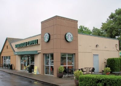
Starbucks is a phenomenon all to itself. It all started when an entrepreneur with a small coffee store in Seattle accidentally burnt some coffee beans in his roaster and could not bear to throw them away. People liked the coffee they made...and a whole empire was born. Now, Starbucks is everywhere...and I have been to many of them. You see, I love their beans for my home use and their coffee when I am on the road. It's strong, dark and delicious, just the way I like it.

In fact, I write these words from inside one of them right now. It doesn't matter where. There is a comfortable sameness about all of them, both in atmosphere and flavor, which is what they tried to achieve...and succeeded.

Anyway, it is around 8:00 AM and the joint is packed. The line inside is long, but moves quickly as two employees are servicing their customers. Outside is an even longer line of cars lined up for the drive-up window. It always amazed me when gas prices were over $4 a gallon how people would queue up in long a line of cars, motors running, just to get a $1.50 to $4.00 cup of coffee. I never waited in that line. In fact sometimes I would park my car, walk in, get my cup of coffee, walk out...and the same cars were still in line. I would lift my cup of coffee in salute to their stupidity and wastefulness. God, I can be holier-than-thou sometimes. Save your gas and save the planet, baby.

This morning the line of cars is so long they are blocking my car from getting out of my parking place...but I am happily ensconced inside for a while...reading, writing, and watching the parade of people. Some are talking, the lady next to me doing a crossword puzzle, the middle aged man across from me reading his paper. Still others like me sitting at their computers doing the Net thing. I am not connected...today I just want to write about what I see.

On this journey, I always look for a Starbucks when I enter a new town. In larger cities I use my GPS to find them. In smaller places, I can usually scope them out as I drive through. Sometimes they are in a grocery store. I found it ironic that for the 16 years I lived in Ephrata there was no Starbucks. For many years, I had them ship me coffee every month automatically until they had so many stores they shut down the mail-order service. Then, as I prepared to leave Ephrata forever, they opened one in the local Safeway. Too late!

On my last trip to London, I was surprised to find them everywhere in that vast city. And they were all doing a thriving business. It didn't surprise me as prior to their arrival, Great Britain had the worst coffee I ever tasted. It was almost always instant. And they thought it was good. Imagine their surprise when they tasted the real deal.

Lest you think that I am a coffeeholic, be advised that I stick or two, sometimes three cups a day, almost always in the morning. And I like it strong. Blame the Italians for that. For years I drank ordinary Mr. Coffee. Then after several weeks in Italy and staying in an Italian home, I could only make strong Italian espresso and cut it with water (here it is called a Cafe Americano). When I got back to America, Mr. Coffee and I separated in a New York minute. It was just too weak. It is Cafe Americano for me.

For this trip, I bought an Italian Espresso coffee pot for $8 and every morning make a cup of Espresso (Starbucks coffee ground for espresso, of course) and cut it with hot water, all done on my camp stove. If I am staying in a hotel or camped near a city, I will come into Starbucks like I did this morning and let them do all the work.

And for a total cost to me of under $2.00, I can sit here and write a blog or browse the Net all day long and get 50 cent refills. I just wish they wouldn't play nostalgic Christmas music.

Wednesday, December 17, 2008

Picture of the Day - Fins with an Arch


It's late in the day and I am ready for bed. But, I wanted to send at least one photo along this day before I retired. This was one of the many fascinating rock formations found in Arches National Park. The formations are called fins and off in the distance you can see an arch has formed on one of the fins. I like this photo since it was one of the few times on this trip to southeastern Utah that I got a few clouds in the sky. Can usually make for a more interesting picture.

A quick note for my friends in Eastern Washington. I see you are being hammered by cold weather and snow. I hope you are all surviving it. As for me, it was 70 degrees here in Tucson today, but mostly cloudy. May actually have some rain tonight. See, it is not all sunshine and fun down here. Stay warm.

Monday, December 15, 2008

Postcard from Las Vegas - Sports Bars and Sports Books


I love football...NFL or college. It has been in my blood since I was a little boy hanging around the 49ers at the old Kezar Stadium in San Francisco, long before football enjoyed the popularity it does today. Frankly, over the years, I have lost interest in watching any other sport. I follow the sports news after football season, but not very closely.

But being on the road during football season has presented its own problems in keeping up with the game. Sadly, I have missed some great games that I would have been watching had I been in a home. Occasionally, I have checked into a hotel on some Sundays just so I can watch a game. But more often than not I will watch them in a sports bar, or when in Las Vegas, in a casino's sports book.

There is a big difference between the two in the atmosphere when watching a game. Take for instance last night. I was watching the last half of the Steelers/Ravens game, and later the Giants/Cowboys game in a sports bar in Tucson. People had on their favorite team jerseys and cheered raucously when their team did something good. It makes the game a lot more fun to watch, at least for me because these fans are passionate.

In a Las Vegas sports book, you hardly ever see a team jersey. The reason is that most observers there are only rooting for teams that will win them a wager. You see, in Vegas, its all about money. The photo you see here is the sports book in The Palms casino (not a great photo as I took it with my cell phone camera). There are TV's everywhere, but the focus of attention is the "big board" where are the games are listed. Here you can bet on the point spread, the over/under, or the Money Line. All that info is listed on the big board. In football, if you bet on the spread and your team is -4 (favored by 4 points), they must win by more than 4 points or you lose the bet.

If you bet the over/under and it is listed as 46, for instance, you would bet on either the over 46 or under 46 for the total points scored during the game. The Money Line is a bit complicated but you can bet straight up without points on a team winning. But if your team is heavily favored, you won't make very much.

Now, all bets must be down before the game starts, although there are some bets posted at half time where you can bet on the second half. But, sometimes, on really important games, there are some special bets you can place...such as which team will score first, or will the first score be a touchdown or a field goal, or will a particular player score a touchdown during the game (in the Super Bowl one year, I saw that you can even bet on the first player to say "Hi Mom" on camera).

But the atmosphere is so totally different in a sports book as opposed to a sports bar. I listen to people expressing there opinions as to which team to bet on and giving thorough information on their expertise. Of course, I listen to them and think if they are so smart, why aren't they rich? But they will give you their "expert" opinion whether you want it or not.

During one college game, the fellow next to me was cheering loudly when one team scored. I was curious so I asked him was he cheering as a fan or because he had money on the game. He said it was all about the money. The team he was cheering was favored heavily and he "gave" the points, but he also bet on the over. His team for that night won big, beating the spread, and they went over the over (if that makes sense). So he did well. I seldom bet on football because then I can't root as a fan...I have to worry about my winning or losing my bet.

In looking at the clock, its time for me to head for my favorite local sports bar for Monday Night Football. Tonight, no money is involved (except for my beer and food)...its all about the fun.

Friday, December 12, 2008

Postcard from Moab, UT - Falling Arches


No, the title doesn't refer to my feet (although I guess it could after some of my hikes), but rather to some of the Arches in the national park. And by the way, the Arches National Park is only 5 miles north of the fun city of Moab, UT. Anyway, in my last blog, I talked a little about how arches are formed. But what I didn't say, but you could probably guess, is that once an arch is formed, that is not the end of the process. No indeed! Arches keep changing and eventually disappear as the water, ice and gravity keep working away.

Near the entrance of the park at a place known as "Park Avenue," there is a road sign that talks about a giant double arch that once existed in this area. You can see the remnants of the of the arches lying on the ground as giant red boulders.

But, the arches I want to focus on today are in the area known as the "Devils Garden." This fantastically beautiful place lies at the end of the Arches main road, very close to the park's only campground. As you can see from, the first photo, the Devil's Garden consists of giant red rock formations known as "fins" because they look so much like a fish's fin. These giants are pushed upward from underneath the ground and form the basis of many future arches.

The photo shows the start of the Devil's Garden trail which takes you to several interesting arches...the most famous being Landscape Arch, the largest arch in the park and the world. It measures some 290 feet from end to end...and is about 1.5 miles from the start of the Devil's Garden trail. This is the subject of the second photo.

One used to be able to walk underneath this arch, but that trail has been closed off for some time. You see, in 1991, a 73 foot slab of rock fell out from underneath the thinnest section of the span. Amazingly enough, a Swiss tourist was there with his video camera when it fell and photographed the whole thing. There were some loud popping noises prior to the actual collapse, so he was able to get his camera up and running. If you would like to see it, click on this link as it is part of a 15 minute movie done by the Discovery Channel that is also shown in the park's theater at the visitor center. It is worth seeing, trust me, just to watch part of the arch fall.

Now, if you continue on the Devil's Garden trail, about a mile beyond Landscape Arch is another famous arch known as Wall Arch...or used-to-be would be a more correct statement. You see, in August of this year, Wall Arch collapsed completely. It apparently happened at night and no one was around. Wall Arch was the 12th largest arch (out of over 2,000, remember) in the park, measuring some 71 feet across and 33 feet high. Obviously, I couldn't take its picture as it was gone when I got there (the trail is closed anyway). However, if you click on this link, you can see a before and an after picture.

The third photo is not an arch, but rather the famous Balanced Rock. I show it hear because it is also subject to the same forces that collapse arches. Someday, perhaps sooner rather than later, it will fall over and probably shatter. No one can predict when it or any of the arches will collapse and fall. It just happens. So as one ranger says in the above-mentioned video, you better come sooner rather than later to see some of these famous natural phenomenon.

Wednesday, December 10, 2008

Postcard from The Arches - What is an Arch?

Of all my visits to western US destinations, The Arches National Park ranks as one of my favorites as it is not only quite beautiful, but absolutely fascinating in a scientific sense . It is a stunning landscape of red rock formed in strange shapes that is wonderful to behold, even if there were no natural arches. But, the arches are the highlight of this fantastic natural show.

According to park information, there are approximately 2,000 (maybe more) known natural sandstone arches in the park. Now that is a big, big number, considering the park is not all that large and a vast portion of the park landscape couldn't possibly hold any arches. Let me explain. When you drive into the park, the first thing you do is climb up over a 1,000 feet very quickly. You emerge on a large desert plain with a lot of empty, nearly flat spaces, but also randomly spaced gigantic rock formations in different sizes and shapes. He is where you find the arches.

Even so, 2,000 seemed like a large number, so I assumed geologists had a rather liberal definition of what constitutes a real arch. Well, I was wrong, as a very patient park ranger explained to me. He showed me a computerized database and books with pictures cataloging each of the arches...some very large and some quite small.

Without getting into great detail, arches are formed by a combination of forces, mostly water, ice and gravity. Wind plays little or no part. Water erodes the sandstone slowly, breaking down the molecular structure of the sandstone...ice expands and contracts inside the rock, weakening it even further, and gravity brings down portions of the rock where the molecular bonds have been weakened beyond the ability of the rock to hold it together. As the park only gets 8"-10" of rain per year, this is obviously a very slow process.

But, what is the definition of an arch? Simply put, an arch has a front entrance and a back entrance. The front, obviously is easy to see, the rear entrance may be large or a small hole at the top or on the sides...AND the rear portion must be at least three feet wide, measured at its widest point. Check out the photos to see what I mean.

The first photo shows a less-than-average-size arch named "Pine Tree Arch," located in the "Devil's Garden" area and named for the small pine tree that grows underneath it. You can gauge the relative size of the arch by the plants growing in front of it. It is most definitely an arch as there is a front and rear entrance.

The second photo shows three huge alcoves in the rocks located near the famous "Double Arch." Even though they are very big, they are not arches as there is no rear or top opening. But, if you notice the opening above the middle alcove. Water will slowly work its way down towards the alcove and one day, long after we are gone, this will be an arch.

The third photo illustrates that size is not important when it comes to arches. This young boy is crawling through a very small opening in the arch. The back of the arch, hidden from view, is wider than three feet, so this is definitely an arch (I forgot the name). Not shown here is another arch in the making only a few feet away. It has it all, except the opening is less than three feet, so it is not an arch...yet.

In upcoming blogs, I will show you some of the largest and most spectacular arches in the park. Stay tuned.

Tuesday, December 09, 2008

Postcard from Tucson - Those Fabulous Arizona Sunsets


This is my only third trip to Arizona...the first actually was just over a year ago. On my second visit last January, I was told by a few people that sunsets in Arizona were usually quite beautiful. And you know what, they were right! I would say that at least 60% of the days I have been here ended in wonderful sunsets.

Now, I know I just wrote about sunrises and sunsets in recent blogs, but having witnessed some of the most beautiful sunsets I have ever seen, I thought I would share a few of the photos I took on these occasions.

A few weeks ago when I first arrived in Yuma, I was talking to my brother on the phone when an amazing sunset began to unfold. I told him to hold on a second and called my daughter-in-law Jill to come outside to see this incredibly beautiful sunset. See came out, saw it, and said, "Oh that happens all the time here," and headed back into the house. I was surprised at first by her supposed lackadaisical attitude to what I perceived to be a once-in-a-blue-moon event, even though she has lived a great portion of her life in this great state. Since that day, I have seen many of these fabulous sunsets myself and can understand why she takes them for granted.

It almost seems that the hand of God goes to work almost every night to arrange this spectacular show. You could have a cloudless day all day long, then all of a sudden, clouds appear in the west in the general vicinity of where the sun will set. When the sun goes down, they light up like a fire in the sky for quite some time. At this point, I just can't stop taking pictures because the show gets better as each minute passes. When it is finally dark, you look up into the western sky and those wonderful clouds are all gone. Then, 24 hours later, the whole show begins all over.

It is just great to be here in Arizona and anticipate the end of each day and what wonders it will bring. If you look backwards in my blog you will find other sunsets I have photographed in Arizona. One of my favorites is of the sunset at the famous mission San Xavier del Bac taken last January.

The first photograph shown here was taken just last night in the Santa Catalina Mountains, about 10 miles north of Tucson. The second photo was taken a few days ago in Madera Canyon, about 40 miles south of Tucson. The third photo was taken in the open desert just a very short way from my son's home. I look forward to more sunsets here.

None have been enhanced digitally other than to apply a small amount of clarity. No saturation was applied. These images are what I saw.

PS - It also helps that we have great weather almost every day.

Monday, December 08, 2008

Picture of the Day - New York Skyline


So have I taken you by surprise and flown to New York as part of journey? Nope. This is not the New York skyline, but rather the skyline of New York, New York, the hotel/casino in Las Vegas. Fooled ya'!

I took this at sunset from the roof of the New York New York parking lot. Although you can't see it in this picture, there is a roller coaster ride that goes all around the inside and outside of this casino. As I was taking this photo, people were screaming as their roller coaster came screaming down a steep incline on its way to take them upside-down before heading back inside the casino. And before you ask, no, I did not ride it.

Las Vegas is a one-of-a-kind twilight zone that is unlike anyplace else in the world. Across Las Vegas Boulevard from New York, New York is Paris, another luxury hotel casino on the strip. The day after I took this photo, I walked the streets of New York New York, then had lunch at a sidewalk cafe outside of Paris that is an exact replica of some of the wonderful sidewalk cafes that I have eaten at in the real Paris. I was fun and as I sat there eating my steak sandwich with frit (french fries) and drinking Beaujolais I could watch the people stroll by my table and see the incredible water show every few minutes across the street at the Bellagio. What a city!

Thursday, December 04, 2008

Postcard from Canyon de Chelly - High Walls and Deep Views

Canyon de Chelly (pronounced SHay) is an enigma in so many ways. First, it is not a National Park, but rather a National Monument. That surprised me, but later I understood why. There is no entry fee and if you want to camp, there is no charge for that either.

When you approach the park on the main highway, you can't see it until you are practically on top of it. It is a cut in the plateau and seems like it should not even be there, but it is. Canyon de Chelly starts out as a single canyon but eventually splits off into two canyons, de Chelly and Canyon del Muerto. Both canyons run for several miles and eventually end. But for me, the entrance to the canyon was very interesting.

It is not like Yosemite where you are suddenly surrounded by 4,000 foot walls. When you approach the canyon after leaving the visitor's center, you see that the canyon entrance is at the same level as you are...in other words, there is no canyon and then you see walls that start rising upward from where you are standing. You also see three roads...the left road will take you upward to overlook the north side of the canyon, the right road will also take you up to see the south side of the canyon, and the middle road (unpaved) will take you into the canyon itself.

Canyon de Chelly sits entirely inside the Navajo Nation. There are several Navajo families living and working the land in the canyon. Therefore, only tribal members can enter the canyon on the center road. There are Navajo-led tours inside the canyon twice a day and cost $50 for 1/2 day and $75 for a full day. Non-Navajo tourists are restricted to the two roads that overlook the canyon. That was a bit disappointing, but I completely understand...which also explains why this is a National Monument.

While I didn't go on the tour into the canyon, I did travel on both roads that have stops at designated overlooks. The south road is by far the most interesting and has more overlooks. The north road has only three overlooks now, although one overlooks a very interesting set of Native American Ruins. In fact, the canyons contain many ruins in various states of decay. They are not Navajo ruins, but rather Anasazi, that enigmatic tribe who inhabited the southwest for many, many years, then suddenly disappeared.

The two most well known overlooks on the south road are the White House Ruins and Spider Rock. The White House Ruins, again built by the Anasazi, from the overlook, are off in the distance and you can almost miss them from the overlook. However, this is the one place that tourists can hike down into the canyon to see the ruins close-up. It is a 1,000 foot drop into the canyon at this point and these old legs chose not to do it.

The last stop on the south road overlook is Spider Rock, a very famous rock that rises up about 900 feet into the air from the canyon floor. If you ever watched the movie "Mackenna's Gold," you know that Spider Rock is a very important element of the film (In fact, IMDB shows that 18 films have been partially filmed in Canyon de Chelly). It's a quite awe-inspiring site to see this site, even from the overlook.

The three photos included here show Spider Rock, the view from the Tseyi Overlook, and the Anasazi Ruins at Mummy Cave Overlook on the north road. It is hard to get any scale when you are shooting down into a canyon, but all the green plant life you see in the first two pictures are actually full size trees. Hope that helps put some scale into the images.

Tuesday, December 02, 2008

Postcard from Southern Utah - Two Views of Church Rock

I was driving north on Highway 191, hoping to get to The Needles in Canyonlands National Park before sunset to set up camp. According to the map, the turnoff to the park was at something called Church Rock. Many miles before the turnoff, at least according to my GPS unit, a large rock formation came into view off in the distance. I couldn't tell the size of it, but instinctively knew it was very big.

By now, I was used to seeing large rock formations in Arizona and Utah, but this was a big one in a very interesting round shape. I wondered at the time if this was Church Rock, and, of course, it turned out it was. But, I drove for many miles seeing the view that you now see in the first picture. I was impressed and knew I wanted to take its picture. So, I stopped very near and took a few images. By now, my GPS unit showed the Canyonlands turnoff just ahead.

I jumped back in the car and headed just a little ways further, then made the left turn towards the park. As I headed down the 34 mile road to The Needles, I glanced in my rear view mirror for one more look at Church Rock. What I saw took me by surprise. What I supposed was a very large round rock, had morphed itself into a huge elongated rock reminiscent in shape to the Sphinx in Egypt.

I turned the van around and drove a little ways back the way I had come to take a quick photo, which is, of course the second photo you see here.

I know this is not an interesting story, but my surprise at the true shape of this rock is worth telling. I don't know anything about the true dimensions of this rock other than it is very big...and I wonder how deep the cave is that you see in the first photo on the lower left side of the first picture. Any answers you may have about this big ol' rock in the desert would be appreciated.

Anyway, that's my story and I am sticking to it.